
In brief
Before the simulation, the pre-analysis shows on the map in which directions the PV areas reflect sunlight over the year. This shows which buildings, roads or flight paths lie in the direction of reflection and where observation points should be placed. It uses no token and does not provide glare times. With differentiated cross tilt, it calculates each area only with the median of its zones.
The reflection directions appear as yellow cones. They show only the direction, not range, height or occlusion; these come only from the simulation (Ch. 12).
11.1 How to
- Meet the prerequisites: at least one PV area with azimuth and tilt (facades without an entry count as 90°, trackers always as complete) and a time zone in the "Project Settings" (Ch. 5).
- Open "Pre-Analysis" at the edge of the map. "Show Entire Year" is preset: one or more cones per PV area covering all directions of the year.
- Click a cone: the window lists the direction range and example times for each PV area. Clicking a time switches to the time view.
- In the time view, choose a time with "Date" and "Time" and check where the reflection points at that moment.
- Under "Settings", adapt the PV areas and the filters to the position of the observers (section 11.3).
- Place observation points where cones point at buildings, roads or flight paths (Ch. 9).
11.2 The "Reflection Pre-Analysis" menu
| Element | Meaning |
|---|---|
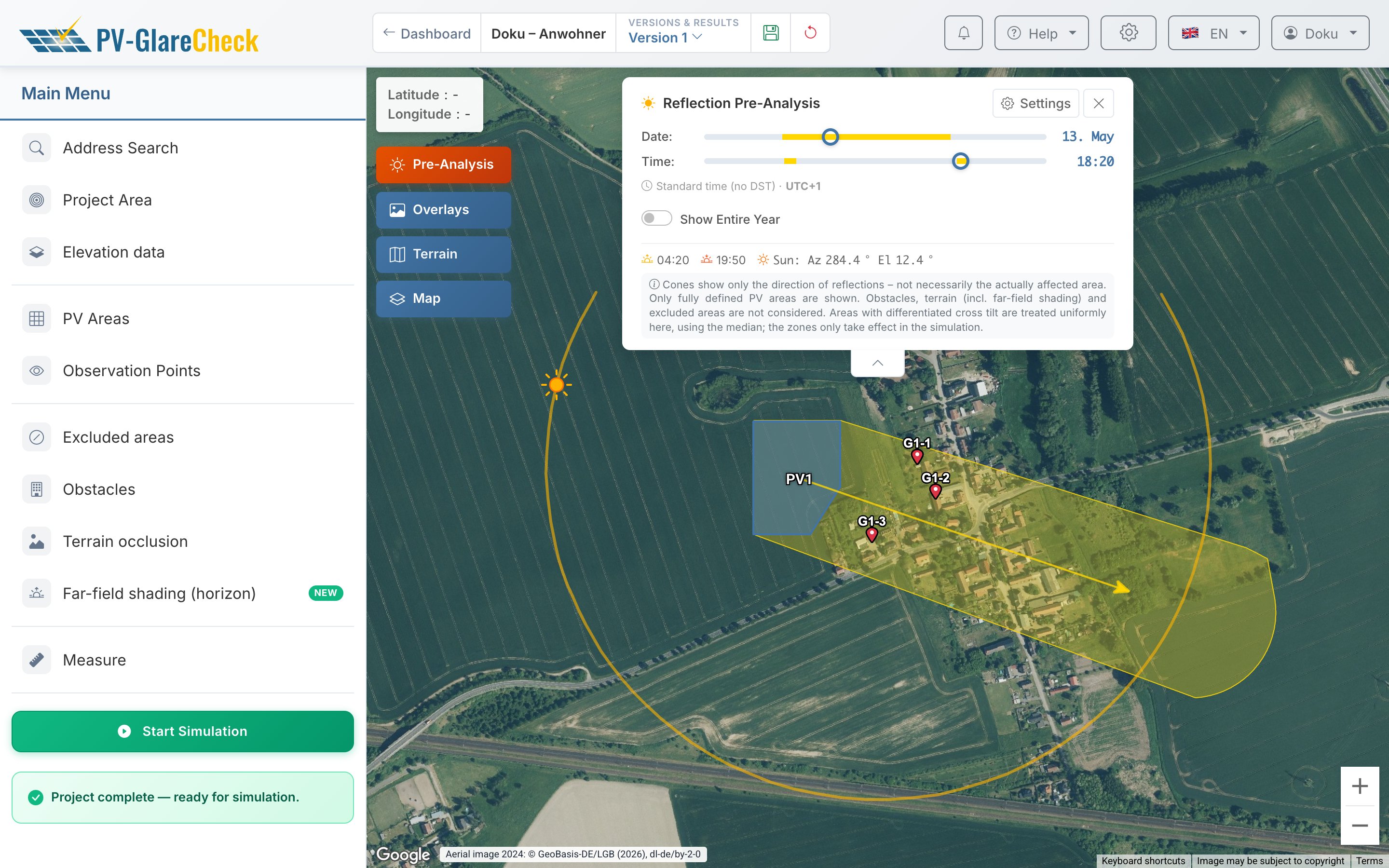
| "Date", "Time" | sliders for the moment shown in the time view. Yellow sections on the sliders show on which days and at which times reflections occur at all, including those lasting only a few minutes a year. In the year view, the sliders are locked. |
| "Standard time (no DST) · UTC+1" | all times are standard time of the project's time zone, without daylight saving time. |
| "Show Entire Year" | on: one or more cones per PV area covering all directions of the year. Off: the time view for the selected moment. |
| sunrise, sunset, "Sun: Az … El …" | sunrise and sunset on the selected day and the position of the sun at the selected moment (azimuth and elevation in degrees). |
| note box | the limits of the pre-analysis in brief (section 11.4). |
| "Settings" | opens the settings (section 11.3). |
| arrow below the menu | minimizes the menu to clear the map; a second click restores it. |
On the map. In the year view, clicking a cone opens a window with the direction range per PV area (e.g. "99–114° (E)") and up to six example times, or up to three per area when several areas overlap. In the time view, one cone per PV area shows the reflection at the selected moment; the arrow points to the middle of the cone. The sun symbol on the arc marks the position of the sun, the arc its path over the day. Arc and cone length are display only: they follow the map view.
11.3 Settings
| Setting | Meaning | Default |
|---|---|---|
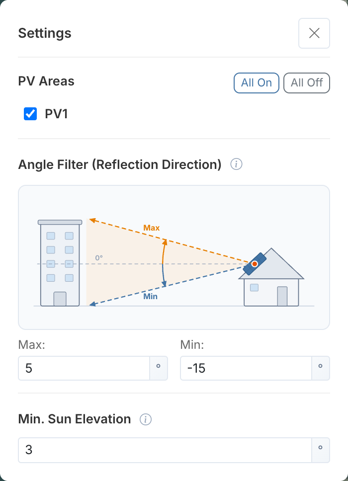
| "PV Areas" | areas included, one checkbox per area; "All On" and "All Off" switch all of them. Incomplete areas are grayed out and marked with a warning symbol (hover text: "Incomplete — finish defining this PV area"). Areas with differentiated cross tilt show the median used, e.g. "median 2°". | all complete ones |
| "Angle Filter (Reflection Direction)", "Max" / "Min" | band of the reflection's elevation angle relative to the horizontal (0°), measured at the PV area; negative is downward, −90° to 90°. Only reflections within this band are shown. The sketch above illustrates how the band relates to the height of the observers. | −15° to +5° |
| "Min. Sun Elevation" | sun positions below this are ignored; 0° to 45° | 3° |
The settings are saved with the project.
Choosing the angle band. An observer Δh lower than the installation at distance d sees the reflection at about −arctan(Δh/d), so 10 m lower at 100 m distance gives roughly −5.7°. For observers above the installation, for example on an upper floor next to a rooftop system or in air traffic, "Max" is raised; the app recommends 30° to 45° for air traffic (Ch. VI.4).
11.4 Points to note
- Cross tilt only as a median. Areas with differentiated cross tilt are calculated by the pre-analysis uniformly with the median of their zones; the cones therefore show an average orientation. The individual zones only enter the simulation (Ch. 7.6). If the zones differ strongly, the real reflection can lie to the side of the cone.
- Outside all cones of a PV area, no reflection from that area reaches a location under the chosen settings. Inside a cone, a location may still be unaffected: the reflection misses it in height, an obstacle lies in between or the area is shaded.
- A band that is too narrow or a high minimum sun elevation hides directions.
- Not taken into account are distance, heights (except via the angle band), obstacles, terrain occlusion, far-field shading, excluded areas and fields of view.
- In read-only versions (Sim-Backup), the pre-analysis is not available; it runs in the working version (Ch. 4).
- A preliminary check according to LAI, Swissolar or the FBA position paper is supported by the pre-analysis only in its direction-related part; it does not cover distance, size or duration criteria (Ch. VI.1, Ch. VI.2, Ch. VI.4).
Details: calculation
- Sun position for the current calendar year in a 5-minute grid for the center of the project area (without a project area: the center of the PV areas), linearly interpolated in between (Ch. V.1).
- Orientation from azimuth, tilt and cross tilt (with differentiated cross tilt, its median); with dual orientation both halves; trackers with the tracking angle including backtracking and stow angle (Ch. 7.3). If the sun hits the rear side, no reflection occurs.
- Reflection lobe of the module type around the specular direction, with reflection offset and elliptical spread per angle of incidence; with several zones the outermost applies, and a perfectly specular module type is given 1° (Ch. 8). If the module type is missing, the pre-analysis reports an error for that area.
- Angle filter: a time counts if the lobe overlaps the band by at least 1° or, for smaller lobes, lies entirely within it. The cone covers only the part within the band.
- Year view: all days in 5-minute steps; gaps of up to 8° in azimuth are closed, larger ones separate the cones.